Statement to AOS2018 : GEOCRI service to SBAs

A Cold Regions Information Service Approach for Societal Benefits
submitted to AOS2018, Davos
1. GEO Cold Regions Initiative
Earth’s Cold Regions, covering the Arctic, Antarctic, high-latitude oceans, Himalaya-Third Pole, and mountain cold areas, are experiencing the fastest rate of climate, ecological and environmental change, which severely affect the entire Earth System. These changes have impacts on more than one hundred countries and on the people living therein, and they also influence many aspects of society and economic development in all parts of the world. Aiming to implement the vision of the intergovernmental Group on Earth Observations (GEO) to address the global environmental change, and its resulting impacts and challenges, the Cold Regions Initiative (GEOCRI) was established to broaden and share Earth observations. GEOCRI will develop a user-driven approach for Cold Regions information services to strengthen synergies and foster collaboration at a global scale, providing coordinated information services across a range of stakeholders to facilitate well-informed decisions and support sustainable development.
2. Information Service Approach
GEOCRI is taking an Information Service Approach to cover the eight Societal Benefit Areas identified by GEO: Biodiversity and Ecosystem Sustainability, Disaster Resilience, Energy and Mineral Resources Management, Food Security and Sustainable Agriculture, Infrastructure and Transportation Management, Public Health Surveillance, Sustainable Urban Development, Water Resources Management and support the global policy. This will ultimately lead to a decision policy supporting the UN Sustainable Development Goals (SDGs) , the Paris Agreement and Sendai Framework for Disaster Risk Reduction.
A Big Earth data-product-information-SBA-Global Policies procedure, the Data Value Chain, provides a data- and knowledge-based value-added chain for an information services mechanism (Fig.1). The GEOSS system and its portal, also connected to a database federation will provide the necessary information basis. Data federation will be organized in strict cooperation with other initiatives, in particular those developed by IASC, WMO and SAON through the Arctic Data Committee (ADC), to take into account the complex and disperse panorama of in polar data repositories/organizations/portals. Also starting from information background, essential cold regions variables will be identified through the domain experts corresponding to the SBAs. Together with them a higher system of indicators will be identified/discussed to directly support the modelling system on the SBAs and global policies.
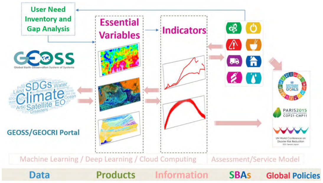
Fig.1 Data Value Chain : an Cold Regions Information Service Approach for Societal Benefits
The Data Value Chain incorporates the entire information services process. It integrates the data providers and data users, transforming data driven information and knowledge in algorithm, including the emerging Big Earth Data, Deep Learning techniques, tools and products for decision makers. Combination of open access satellite data, in-situ observations and modelling prediction is fundamental for this chain and should/will be largely explored in order to identify all potentialities for societal benefits areas.
3. Implementation Developments
The GEOCRI initiative includes infrastructure networking, a data federation system, essential variable identification, and best practices for the selected SBA priorities covering the cold regions. The Implementation Plan of GEOCRI is grouped into five tasks: Infrastructures, Monitoring Network and Data, In-situ and Remote Sensing Integration, User Engagement and Capacity Building, and Management and Monitoring. A co-lead group was established to envision and implement this aim.
Recent key developments and synergy activities for implementing this information approach in GEOCRI include, but are not limited to:
- The infrastructure task works on strengthening the collaboration between infrastructure networks and operators by sharing of best practices, for example, to leverage improved research infrastructure accessibility beyond the Arctic to other cold regions. The focus is on helping to identify the gaps and potential overlap in Earth observing capacity, and on the integration and interoperability of in-situ and remotely sensed Earth observations in cold regions across the environmental, ecological and societal domains. This component is working with the different international communities relevant to the Earth’s cold regions, especially the Committee on Observations and Networks (CON) for Sustaining Arctic Observing Networks (SAON), and etc
- Building on broader data sharing principles, GEOCRI is working in partnership with international and national organizations to achieve substantial progress in making cold regions research and monitoring datasets discoverable and available to the broadest range of users. Progress is being made through and leverage the GEOSS data infrastructure and its community portal function. Recently, GEOCRI has partnered with the Arctic Data Committee of the International Arctic Science Committee (IASC) and the SAON program and other polar region organizations to work towards a federated search network that will further increase our ability to find important, high quality data.
- The Essential Cold Region Variables (ECRVs) currently developed in GEOCRI and in collaboration with several other actors, like international and national Arctic and cryosphere science bodies, are the key to bridge the Earth observations infrastructure, data and societal benefits. The ECRVs will include a set of identified variables related not only to purely climate and environment, but also to the societal and economic development over the Earth’s cold regions. These essential variables, once in place, can help to estimate how and to what extent the Earth Observations support the global policy, like UN Sustainable Development Goals (UN SDGs), and the Paris agreement through GEO’s well-established international cooperation.
- The indicators/variables and users/stakeholders can be connected through the user needs and knowledge gap analysis actions. These will be used by GEOCRI to show where future research investments would have to focus to gain a more complete understanding of cold regions, especially Arctic systems. A combination of interviews and a standardized survey are used to develop a database that will numerically demonstrate the key research needs, user needs of Canada’s Arctic population are being researched in a comprehensive study that will feed into GEOCRI. Available information from recently completed synthesis reports (i.e. Arctic Biodiversity Assessment, Arctic Climate Impact Assessment) is reviewed and key knowledge gaps are identified by Polar Knowledge Canada.
Improved understanding and collaboration across the Earth’s Cold Regions, together with data sharing and its federation mechanism, efficient information flow, better-integrated observing capacity, will help to assist timely and effective decision-making to reach societal benefits and support sustainable development in these regions and beyond.
What happens in the cold regions affects the entire Earth System and humankind across the globe. The GEOCRI’s international observation science collaboration and understanding of the Earth’s Cold Regions, and information service provide an endeavour for a better society.
Download: P4-6 https://arcticobservingsummit.org/wp-content/uploads/2021/06/AOS2018_short_statements_WG4.pdf